Weather Systems
As discussed on the atmosphere page, the heat received from the Sun is not evenly spread across the globe, with a positive heat balance at the tropical latitudes, and a negative energy balance at the Poles. These global variations in temperature result in pressure differences in the air. This is because warmer air becomes less dense and rises, creating areas of low pressure, and colder air is denser so therefore sinks, creating areas of high pressure. The atmosphere seeks to balance out the uneven distribution of heat energy budget and pressures at the different latitudes in several different ways.
Planetary Surface Winds
The global differences in areas of high and low pressure, positive and negative energy, result in winds, horizontal movements of air, moving air from areas of high pressure to low pressure to maintain the global energy balance.
Where there are differences in pressure between places, a pressure gradient exists. Without the Coriolis effect, wind would blow air straight out of a high pressure location to a low pressure location. But the Coriolis efffect means that this happens in a spiraling motion:
- around a low pressure system, air spirals inwards in an anti-clockwise direction (in Northern Hemisphere)
- around a high pressure system, air spirals outwards in a clockwise direction (in Northern Hemisphere)
At the global scale there are three global planetary surface wind systems:
- the northeast and southeast trade winds, which blow towards the Equator from the subtropical 'high 'to the ITCZ (inter-tropical convergence zone)
- the westerly winds, which blow towards the poles from the subtropical 'high' to the sub-Arctic 'low'
- the polar easterly winds, blowing outwards from high pressure over the Poles
These planetary surface winds are an important climate control. In middle and high latitudes, westerly winds bring characteristically unsettled weather, with "families" of depressions alternating with ridges of high pressure or 'anticyclones'. The influence of the trade winds in the tropics and subtropics depends on whether they blow onshore or offshore. Onshore trade winds will create hot and humid conditions with heavy rainfall (e.g. Brazil & SE Africa). Offshore winds will be dry and are partly responsible for hot desert climates (e.g. NE & SW Africa).
Low Pressure Systems
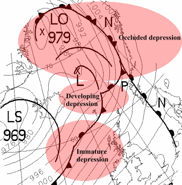
Low pressure weather systems are also known as depressions or cyclones. These are areas of low atmospheric pressure due to a mass of warm air rising, cooling and condensing, as it can no longer hold as much water vapour. The water condenses into water droplets and forms clouds, meaning a higher change of rainfall. These low pressure systems often form in the Atlantic,then move eastwards towards the UK and are responsible for the UK's changeable unsettled weather. Low pressure systems are the most common system in the UK.
Depressions are triggered in locations where the jet stream accelerates, and the North Atlantic is one such location where this happens, so the area south of Iceland is a very common location for depressions forming. As the jet streams meander across the Atlantic, whole families of depressions can be triggered along the same jet stream. These are known as secondary depressions (see diagram below) and are difficult to forecast!
High Pressure Systems
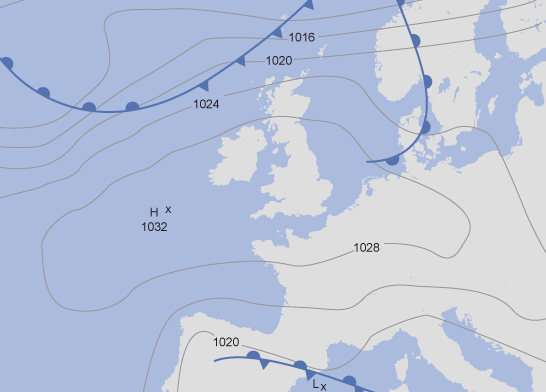
High pressure weather systems are also known as anticyclones. These are areas of high atmospheric pressure where cold air is sinking. As the cold air sinks, it warms, meaning it can hold more water, so no clouds or rain are formed. The absence of fronts means that winds can be very light. This means that anticyclones are associated with settled, dry and bright conditions. In the summer, anticyclones bring dry, hot, clear and sunny weather (see synoptic chart below for a typical summer anticyclone), and in the winter they also bring clear dry weather, but very cold, with cold nights and frost. Anticyclones in the winter may also bring fog and mist, because the cold forces the moisture in the air to condense at low altitudes.
Fronts
Fronts are boundaries and occur when two different air masses meet.
Warm fronts
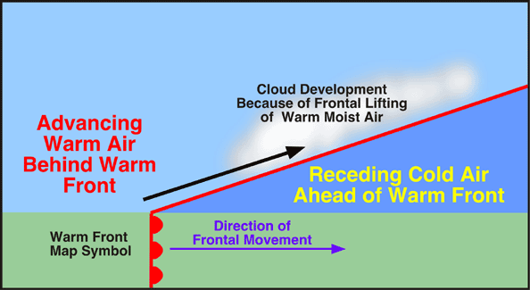
Warm fronts occur when warm air rises over a mass of cold air. This is because warmer air is less dense than the cold air, and replaces the cooler air at the surface. Pressure falls. As the warm front approaches there is a gradual deterioration in weather. Clouds gradually lower from cirrus, down through altostratus, to stratus and nimbostratus. There is often a prolonged spell of heavy rainfall. Behind the front the rain becomes lighter, turns to drizzle or stops altogether. Cloudy weather tends to follow.
The diagram below shows the atmospheric cross-section of a warm front.
Fronts are boundaries and occur when two different air masses meet.
Warm fronts
Warm fronts occur when warm air rises over a mass of cold air. This is because warmer air is less dense than the cold air, and replaces the cooler air at the surface. Pressure falls. As the warm front approaches there is a gradual deterioration in weather. Clouds gradually lower from cirrus, down through altostratus, to stratus and nimbostratus. There is often a prolonged spell of heavy rainfall. Behind the front the rain becomes lighter, turns to drizzle or stops altogether. Cloudy weather tends to follow.
The diagram below shows the atmospheric cross-section of a warm front.
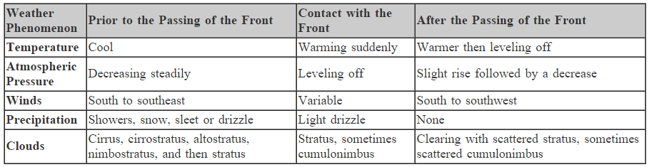
Summary of a warm front
Cold fronts
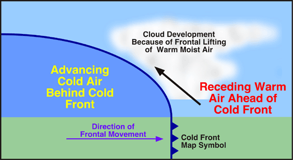
A cold front occurs when cold air is advancing and pushing underneath the mass of warmer air at the surface. As the warm air is pushed upwards and the front passes it will rain heavily for a short spell, occasionally with thunderstorms and cumulonimbus clouds. Behind the front the weather is usually much brighter with broken cloud but occasional showers.
The diagram below shows the atmospheric cross-section of a cold front.
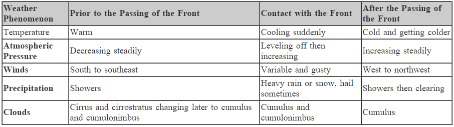
Summary of a cold front
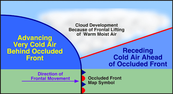
Occluded fronts
Occluded fronts occur when a fast-moving cold front takes over a slow-moving warm front (the opposite can also happen). If a cold front undercuts a warm front then it is known as a cold occlusion and if the cold front rises over the warm front then it is known as a warm occlusion. Occluded fronts bring changeable weather conditions
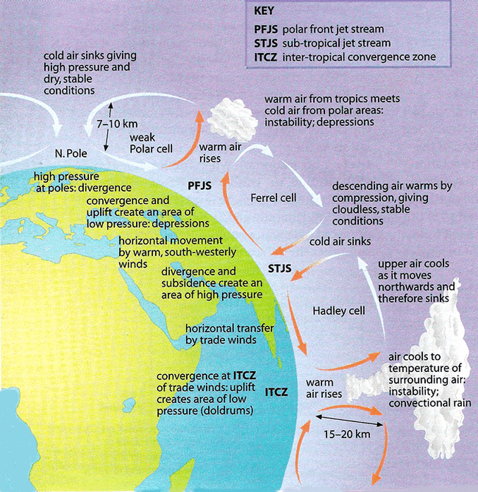
The Tri-Cellular Model
The general model to explain the atmospheric circulation is known as the tri-cellular model. This model helps to explain the differences in pressure belts, temperatures and precipitation, and how the atmosphere tries to equalise the differences in energy of the global heat budget between the poles and the equator. The tri-cellular model is made up of three cells: the Hadley Cell, the Ferrel Cell, and the Polar Cell. These are shown in the diagram below, where it can be seen that the boundaries of each cell coincides with particular latitudes. There is a mirror image of this in the Southern Hemisphere, from the Equator to the South Pole.

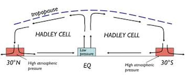
Hadley Cells
The Hadley Cell operates between the Equator and 30 degrees North, and the Equator and 30 degrees south. At the Equator, trade winds meet and form the Inter-Tropical Convergence Zone. Winds are light and known as the doldrums. There is intense low pressure as air is warm and unstable having crossed warm oceans. It rises due to convection currents and cools, forming large cumulonimbus clouds.
Eventually, the rising air has cooled to the same temperature as its surroundings and begins to spread out, forming a belt of clouds. The air flows horizontally, some flowing northwards and some migrates southwards in the Hadley Cell of the Southern Hemisphere. The air falls at approximately 30 degrees north and south of the Equator, the descending limb of the Hadley Cell, which creates an area of high atmospheric pressure. The sinking air is compressed and warmed, preventing cloud formation. The result is clear skies, intense heating at the surface, permanently dry weather and the formation of the world's great tropical deserts and the subtropical 'high' pressure belt.
Some of this air migrates back at ground level to the low pressure area at the Equator, completing the last limb of the Hadley Cell, whilst the rest of the air continues migrating north at ground level as warm south-westerly winds towards 60 degrees north, forming the lower limb of the Ferrel Cell.
The Hadley Cell is thermally direct, as it powers itself, directly converting thermal energy into kinetic energy. Its rising limb over a warm temperature zone and sinking limb over a cold temperate zone.
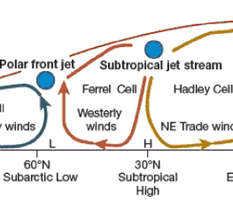
Ferrel Cells
The Ferrel Cell operates between 30 and 60 degrees North, and between 30 and 60 degrees South. It is responsible for the climates occurring in the mid-latitudes. The air at ground level travelling north on the lower limb of the Ferrel Cell is referred to as the warm southwesterlies in the northern hemisphere and the northwesterlies in the southern hemisphere. These winds pick up moisture as they are warm and travel over oceans.
When they reach 60 degrees North, they meet cold polar air that is migrating south. This forms another convergence zone where two surface air streams meet. The warm air is less dense so rises over the colder denser air, which creates areas of low pressure and it is where the Polar Front Jet Stream is located. Because of the low pressure, mid-latitude weather systems such as depressions form, which are characteristic of our Cool Temperate Western Maritime Climate.
As the rising warm air of the upward limb of the cell, some of the air returns to the Tropics as part of the Ferrel Cell, and some is diverted northwards into the Polar Cell.
The Ferrel Cell is thermally indirect. This cell rises over a cold temperature zone and sinks over a warm temperature zone. The cell is not driven by thermal energy but by weather systems, and the other two thermally direct cells.
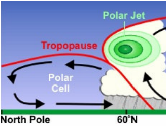
Polar Cells
The Polar Cell is much smaller than the other two, and like the Hadley Cell, it is thermally direct. It operates between 60 degrees north and the North Pole, and 60 degrees south and the South Pole. Descending cold air at the Poles results in high pressure in the polar regions. This causes surface air to migrate easterly towards the mid-latitude low pressure belt.
The Polar Cell is much smaller than the other two, and like the Hadley Cell, it is thermally direct. It operates between 60 degrees north and the North Pole, and 60 degrees south and the South Pole. Descending cold air at the Poles results in high pressure in the polar regions. This causes surface air to migrate easterly towards the mid-latitude low pressure belt.
The Model
The model has many applications and limitations. It does not take into account other major energy transfers, such as the El Nino or La Nina circulations across the Pacific Ocean, and it does not acknowledge any natural obstacles which can disrupt the movement of jet streams and winds which can affect the cells. However, it does offer a very good starting point for people to understand atmospheric circulation, and some prediction of weather conditions.
The model has many applications and limitations. It does not take into account other major energy transfers, such as the El Nino or La Nina circulations across the Pacific Ocean, and it does not acknowledge any natural obstacles which can disrupt the movement of jet streams and winds which can affect the cells. However, it does offer a very good starting point for people to understand atmospheric circulation, and some prediction of weather conditions.